GS1 Urbanisation

A brief downpour exposed deeper urban planning challenges, reminding us that resilient cities are built long before the rain arrives.

Hyderabad Floods and Traffic Paralysis: When Urban Growth Ignores Geography

Examining how a brief downpour caused chaos in Cyberabad's IT hub, questioning urban planning, drainage, and infrastructure resilience.
Surya Surya
4 mins read

The massive traffic gridlock that paralysed Hyderabad's western IT corridor on June 9, 2026, was not merely the result of heavy rainfall. It exposed the interaction between natural geography, rapid urbanisation, inadequate drainage planning, and transportation vulnerabilities.

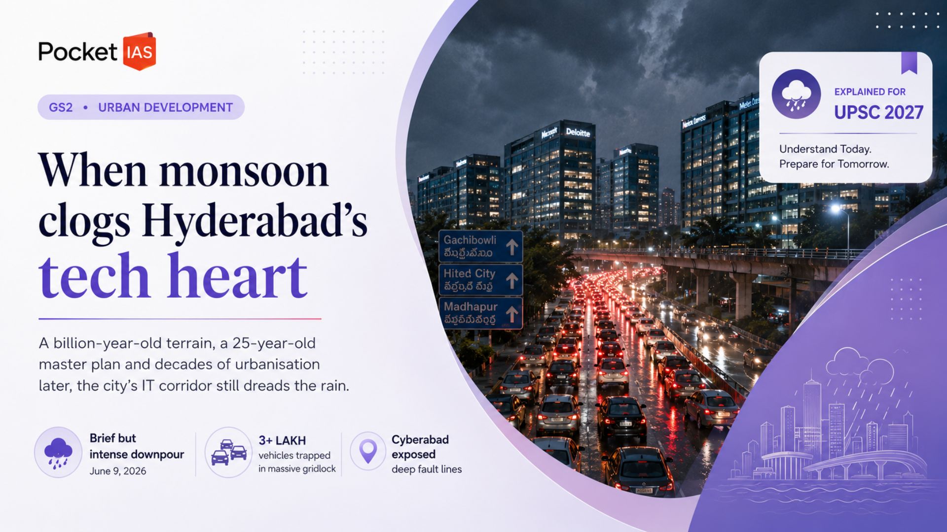
A Rainfall Event That Brought a City to a Halt

When intense evening thunderstorms struck Hyderabad's IT corridor, lakhs of commuters found themselves trapped in unprecedented congestion.

ImpactDetails
Vehicles affectedOver 3 lakh
Rainfall intensityNearly 57 mm in one hour in some areas
Commute delaysUp to 3–4 hours for short distances
Area occupied by stranded vehiclesAbout 824 acres (3.34 sq km)

"Just a few minutes of rain brought the entire traffic system to its knees." — Commuter account

The disruption occurred precisely during peak office exit hours, amplifying the impact.

Why Did the Rainfall Occur?

According to IMD meteorologists, the rainfall was a typical pre-monsoon thunderstorm event.

Meteorological Factors

  • Prolonged temperatures between 41°C and 46°C heated the land surface.

  • Temperature differences attracted moisture-laden winds from:

    • Arabian Sea
    • Bay of Bengal
  • Formation of cumulonimbus clouds triggered intense localised rainfall.

Pre-Monsoon vs Monsoon Rainfall

Pre-Monsoon ThunderstormsMonsoon Rainfall
LocalisedWidespread
Short durationSustained
High intensityModerate intensity
Driven by afternoon heatingSeasonal circulation

"Such thunderstorms are a common summer phenomenon following prolonged periods of intense heat." — IMD Hyderabad

The Real Issue: Geography Meets Urbanisation

Experts argue that rainfall alone does not explain the flooding.

Western Hyderabad differs significantly from older parts of the city.

Older HyderabadWestern Hyderabad
Relatively flat terrainHills and valleys
Natural drainage less steepComplex slopes and channels
Lower runoff velocityRapid downhill water flow

Historically, rainwater flowed through natural drainage paths into water bodies such as Durgam Cheruvu.

However, rapid urban development altered these pathways.

Key Problems

  • Construction over natural drainage channels.
  • Encroachment of low-lying areas.
  • Extensive concretisation reducing water absorption.
  • Ignoring geological contours during development.

"Office and residential buildings have come up along the natural pathways, blocking water flow." — Hari Sarvothaman, University of Hyderabad

Cyberabad's Planning Challenge

The roots of the problem trace back to Cyberabad's development model.

1998 → Cyber Towers established
2001 → Cyberabad Development Authority formed
2001 → Master Plan implemented
2013 → Land-use modifications in some areas
2026 → Major flooding and traffic paralysis

Although a master plan existed, critics highlight:

  • Limited integration of geological expertise.
  • Alteration of planned infrastructure corridors.
  • Land-use changes in vulnerable zones.

These decisions increased flood susceptibility over time.

Why Small Rainfall Amounts Create Big Urban Floods

Urban flooding is amplified by impervious surfaces.

IMD's Illustration

5 cm rainfall over 1 sq km
=
50,000 cubic metres of water
=
Nearly 50 million litres
=
Around 10,000 water tankers emptied simultaneously

With limited infiltration:

  • Water accumulates rapidly.
  • Roads become temporary channels.
  • Flood depths can reach 60–100 cm.
  • Traffic movement collapses.

Why Traffic Became Unmanageable

The rainfall coincided with office closing hours across the IT corridor.

Sequence of Events

  1. Rain began around 5 p.m.
  2. Employees entered road network simultaneously.
  3. Waterlogging emerged at vulnerable junctions.
  4. Congestion spread across connected roads.
  5. Entire corridor entered gridlock.

Major bottlenecks included:

  • Biodiversity Junction
  • Cyber Gateway
  • Hitec City Main Road
  • IKEA Flyover

Authorities admitted that once the vehicles had entered the network, large-scale diversions became nearly impossible.

Emerging Urban Governance Lessons

The event revealed:

  • New flood-prone zones.
  • Inadequate real-time forecasting integration.
  • Need for dynamic traffic management.
  • Limits of conventional drainage solutions.

Even successful drainage improvements in some locations shifted flooding elsewhere, creating new vulnerabilities.

Way Forward

  • Restore and protect natural drainage corridors.
  • Integrate geological and hydrological assessments into urban planning.
  • Expand permeable surfaces and rainwater infiltration systems.
  • Implement real-time weather-linked traffic management.
  • Enforce stricter land-use regulations in low-lying zones.
  • Develop urban flood modelling and digital monitoring systems.
  • Encourage staggered office timings during severe weather alerts.

Conclusion

The Hyderabad floods demonstrate that urban flooding is not solely a climatic issue but also a planning challenge. While intense rainfall acted as the trigger, the underlying causes lie in altered drainage patterns, unchecked concretisation, and development that overlooked natural geography. Building resilient cities requires aligning future urban growth with ecological and geological realities rather than attempting to overcome them through infrastructure alone.

Attribution

Original content sources and authors

Lavpreet Kaur Author Lavpreet Kaur The Hindu Source The Hindu

Syllabus classification

How this article maps to GS papers

Main syllabus

GS1Urbanisation

Also covers

GS3Environment & Bio-diversityGS1Geography

Quick Q&A

What are the major causes of urban flooding in Hyderabad and what do they reveal about the challenges of contemporary urbanisation in India?
Urban flooding refers to the temporary inundation of land and infrastructure in built-up areas due to excessive surface runoff and inadequate drainage. The June 9, 2026 flooding and traffic paralysis in Hyderabad illustrate how natural processes and unplanned urbanisation interact to create disasters. According to IMD officials, temperatures ranging from 41°C to 46°C generated intense convection and cumulonimbus clouds, resulting in highly localised rainfall. Nearly 57 mm of rain reportedly fell within an hour in some pockets, while around 11 cm of rainfall was recorded in certain areas. However, meteorologists and geologists emphasise that rainfall intensity alone does not explain the crisis. Western Hyderabad's terrain consists of hills, valleys and natural drainage channels that historically directed runoff into water bodies such as Durgam Cheruvu. Rapid urbanisation since the late 1990s, particularly the rise of Cyberabad, led to construction along these natural pathways. Increasing concretisation reduced infiltration, while drainage infrastructure failed to keep pace with growth. Experts note that a 5-cm rainfall event over one square kilometre can generate nearly 50 million litres of water. Such runoff overwhelms drainage systems, causing waterlogging and cascading traffic failures. Critics also point to modifications in the Cyberabad Master Plan and inadequate integration of geological expertise. For UPSC, this topic connects with GS-I (Urbanisation and Geography), GS-III (Disaster Management and Environment), and governance issues relating to sustainable cities. It highlights the importance of integrating ecological principles into urban planning and demonstrates that many urban disasters are anthropogenic rather than purely natural phenomena.
Why is the Hyderabad flooding episode significant for understanding climate resilience, infrastructure planning and governance in Indian cities?
The Hyderabad flooding episode is significant because it demonstrates that urban resilience depends as much on governance and infrastructure planning as on meteorological factors. Although climate variability contributes to extreme weather events, experts argue that urban flooding is largely a manageable infrastructure challenge rather than an inevitable consequence of climate change. The event exposed multiple vulnerabilities. More than three lakh vehicles reportedly became trapped in gridlock, affecting major IT hubs such as Gachibowli and Hitec City. Commuters spent several hours covering distances of only a few kilometres, revealing the economic and productivity costs of inadequate infrastructure. Since Hyderabad is aggressively promoting itself as a destination for Global Capability Centres and international investment, such incidents also affect investor confidence and urban competitiveness. The crisis further highlighted weaknesses in forecasting, emergency preparedness and inter-agency coordination. Authorities admitted that advisories were issued too late and that response teams themselves faced difficulty reaching affected areas. This raises questions regarding early-warning systems and adaptive governance. From a broader perspective, the incident aligns with Sustainable Development Goal 11 relating to sustainable cities and communities. It reinforces recommendations of the National Disaster Management Authority regarding urban flood management and integrated planning. For UPSC aspirants, the topic has relevance to GS-II (Governance), GS-III (Infrastructure and Disaster Management) and interview discussions on climate adaptation. It also illustrates the growing debate between viewing extreme weather events solely through the lens of climate change versus recognising the role of planning failures, institutional weaknesses and unsustainable urban growth patterns.
How did Hyderabad's geographical characteristics and historical urban development patterns contribute to the June 2026 flooding crisis?
The June 2026 flooding in Hyderabad demonstrates how geography and historical urban development interact to shape disaster risks. Western Hyderabad differs significantly from relatively flatter areas such as Charminar, Secunderabad and Nampally. The region contains undulating terrain characterised by hills, valleys and natural drainage channels formed over geological timescales. Historically, rainwater flowed naturally through these gradients into lakes and catchment areas such as Durgam Cheruvu. However, the expansion of the IT sector during the late 1990s transformed the region into Cyberabad. The Cyberabad Development Authority was established on January 20, 2001, and a master plan prepared by Vastu Silpi Consultants under the leadership of renowned architect B.V. Doshi came into force on October 29, 2001. Although the original plan attempted to respect topography, critics argue that geologists were not adequately involved in planning. Subsequent modifications altered land-use patterns. For example, a 2013 government order redesignated a proposed 24-metre road in Gopanpally and Manikonda into residential land, affecting drainage characteristics. Rapid construction of commercial complexes and gated communities along natural water pathways obstructed runoff. Simultaneously, permeable surfaces were replaced by concrete, reducing groundwater recharge and accelerating surface flow. Consequently, even moderate to intense rainfall resulted in waterlogging depths of 60 cm to 100 cm. For UPSC preparation, this case demonstrates the importance of integrating geography, environmental science and urban governance. It relates to GS-I topics on physical geography and urbanisation and GS-III themes concerning disaster management. It also reinforces the principle that ignoring natural contours in city planning creates long-term vulnerabilities and increases disaster risks.
What were the institutional and governance-related reasons behind the severe traffic gridlock witnessed during the Hyderabad rainfall event of June 2026?
The severe traffic gridlock in Hyderabad during June 2026 resulted from a combination of meteorological uncertainty, institutional limitations and inadequate urban mobility planning. According to Cyberabad Traffic Police estimates, over three lakh vehicles were caught in congestion across the western corridor. The scale of the disruption demonstrated how quickly transportation systems can collapse when exposed to sudden shocks. One major reason was the timing of the rainfall. The downpour coincided with the evening peak hours when lakhs of employees from the IT corridor were leaving offices. Key junctions such as Biodiversity Junction, Hitec City Main Road and the IKEA flyover became choke points, and congestion spread rapidly across interconnected roads. Another factor was the absence of precise short-term forecasting. Traffic officials acknowledged that authorities lacked accurate predictions and were unable to implement diversions before roads became saturated with vehicles. Advisories regarding staggered office timings were issued around 4:30 p.m., but they proved ineffective because commuters were already entering the transport network. Institutional coordination challenges further aggravated the crisis. Emergency personnel and municipal workers themselves struggled to reach affected locations because roads had become impassable. The event exposed the limitations of reactive governance and highlighted the need for anticipatory systems. The episode also raises larger questions regarding urban transport planning, dependence on private vehicles and the absence of dynamic traffic management systems. For UPSC aspirants, this topic relates to GS-II governance issues, GS-III infrastructure and smart cities, and public administration themes concerning disaster preparedness, interdepartmental coordination and crisis management. It illustrates that resilience depends not only on physical infrastructure but also on institutional capacity.
Critically analyse whether climate change alone can explain the increasing frequency of urban flooding events in Indian metropolitan cities.
Urban flooding has increasingly been associated with climate change, but attributing every flooding event solely to climate change oversimplifies a complex issue. The Hyderabad experience of June 2026 provides a useful case study for analysing this debate. Climate change undoubtedly contributes to rising temperatures, increased atmospheric moisture and a greater probability of extreme precipitation events. Pre-monsoon thunderstorms driven by intense heating are expected to become more frequent under warming scenarios. Therefore, changing climate conditions constitute an important risk multiplier. However, experts such as IMD meteorologists argue that urban flooding is often primarily a consequence of infrastructure deficiencies and ecological degradation. In Hyderabad, blocked drainage channels, extensive concretisation, encroachments on natural watercourses and poor integration of geological knowledge significantly amplified the impact of rainfall. Similar patterns have been observed during floods in Chennai (2015), Bengaluru (2022) and Mumbai (2005). Another perspective highlights governance failures. Weak enforcement of land-use regulations, fragmented urban institutions and delayed emergency responses often transform heavy rainfall into disasters. Consequently, climate change acts as a trigger, while human-induced vulnerabilities determine the magnitude of losses. A balanced assessment suggests that urban flooding should be viewed through the framework of risk = hazard + exposure + vulnerability. Climate change increases hazards, whereas poor planning increases exposure and vulnerability. For UPSC, this issue is relevant to GS-III topics on environment and disaster management and to essay themes on sustainable development. A critical understanding requires acknowledging both environmental and governance dimensions rather than adopting deterministic explanations centred exclusively on climate change.
What lessons and policy measures can Indian cities derive from the Hyderabad flooding episode to promote sustainable and resilient urban development?
The Hyderabad flooding episode offers valuable lessons for Indian cities experiencing rapid urbanisation. It demonstrates that infrastructure expansion without ecological sensitivity can create systemic vulnerabilities that undermine economic growth and quality of life. One key lesson is the necessity of preserving natural drainage systems, lakes and floodplains. Construction activities must respect topographical and geological realities. Urban master plans should incorporate inputs from geologists, hydrologists and climate experts alongside engineers and architects. Secondly, drainage infrastructure needs substantial upgrading. IMD experts noted that 5 cm of rainfall over one square kilometre can generate nearly 50 million litres of water. Therefore, storm-water systems must be designed to accommodate extreme rainfall events rather than historical averages. Thirdly, technological interventions such as digital monitoring, GIS mapping, real-time rainfall forecasting and intelligent traffic management systems can improve preparedness. Public awareness campaigns, compliance audits and penalties for violations can strengthen urban governance. Green infrastructure, including permeable pavements, rain gardens and urban wetlands, should be promoted to enhance groundwater recharge and reduce runoff. Institutional coordination among municipal corporations, traffic police, meteorological agencies and disaster management authorities is equally essential. Flexible office timings and promotion of public transport can minimise peak-hour vulnerabilities. Several Indian cities, including Chennai and Bengaluru, have begun experimenting with integrated flood management approaches. International examples from Singapore and the Netherlands demonstrate the effectiveness of water-sensitive urban design. For UPSC aspirants, these lessons relate to GS-II governance, GS-III infrastructure and environment, and themes concerning sustainable development and Smart Cities Mission. They highlight the need to move from reactive disaster response towards proactive and resilient urban planning.

Practice questions

1 question for mains preparation

Examine how rapid urbanisation and the neglect of natural drainage systems have increased the vulnerability of Indian cities to urban flooding . Illustrate your answer with suitable examples.

10 marks · 150 words · 8 mins